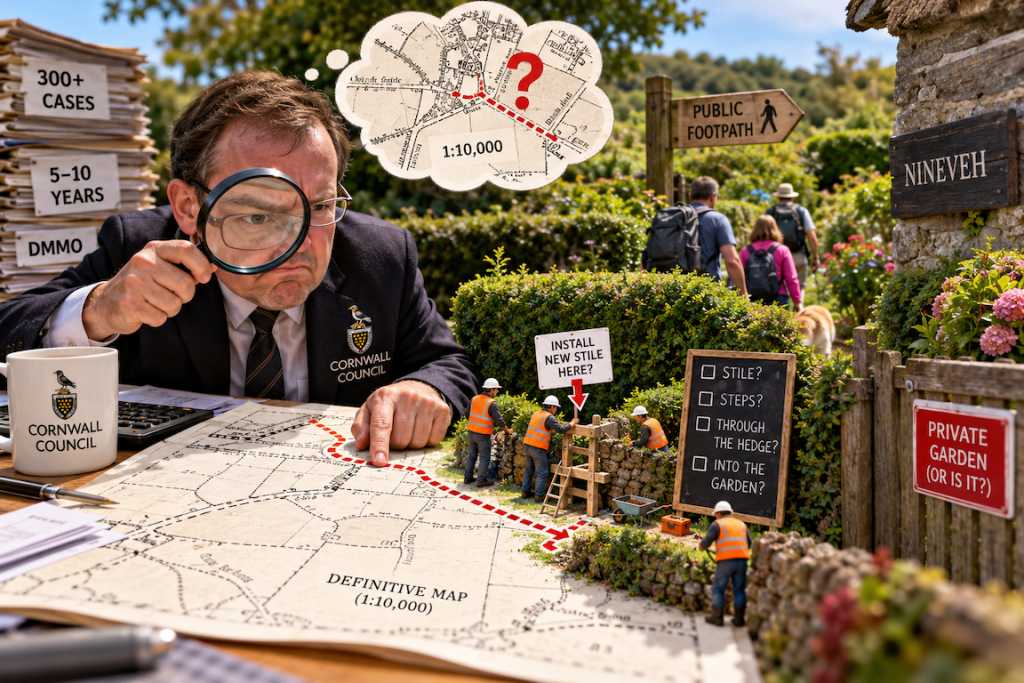
There’s something rather magical about modern technology.
You can take a fuzzy old map, draw a line on it, feed it into a computer, and suddenly that line becomes extraordinarily precise.
So precise, apparently, that Cornwall Council can use it to tell me a public footpath runs through my house.
Or my garden.
Or a building that’s been standing there for rather a long time.
And then tell me the footpath is obstructed.
Welcome to Part IV.
For anyone who hasn’t been following this increasingly ridiculous saga, Cornwall Council granted us planning permission in August.
Wonderful.
Unfortunately, the decision also declared that two public footpaths across our property were already obstructed and that we would need to pay for formal diversion orders.
We’ve spent the weeks since trying to understand precisely what evidence justified those conclusions.
And in the process, I’ve discovered something rather interesting.
Cornwall Council’s own website warns that its Definitive Map may not accurately represent intricate changes in the direction of a footpath.
Oh, for fuck’s sake.
One centimetre. One hundred metres.
The Definitive Map is the legal record of public rights of way.
I know this because Cornwall Council has told me.
Several times.
I don’t dispute it.
But here’s what the Council also says on its own website:
“The line that is drawn on the Definitive Map may not show intricate changes in the direction of a path.”
Why?
Because the original map was generally drawn at a scale of 1:10,000.
One centimetre represents 100 metres.
One millimetre represents 10 metres.
Think about that for a moment.
Ten fucking metres.
Now consider the difference between a footpath running alongside a building and one running through it.
Or a footpath following the outside of a substantial Cornish stone hedge and one passing into the private garden behind it.
Those distinctions can matter enormously on the ground.
But how accurately can they be resolved from a line on a map drawn at that scale?
The Council acknowledges that the original line may not capture intricate changes of direction.
Yet somehow we’re now looking at a highly detailed digital representation, overlaid on modern buildings, which is being interpreted as though it can settle those distinctions.
Where did the additional precision come from?
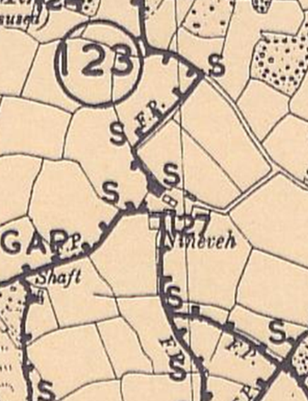
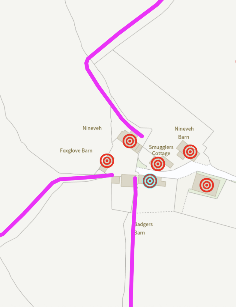
I’m not suggesting somebody deliberately invented a footpath.
I’m asking a much simpler question.
How do you take a record that acknowledges its own limitations and produce something that appears to have none?
And, more importantly, what evidence justifies treating that apparent precision as fact?
The footpath that apparently changed its mind
Let’s return to the historical evidence.
We have an Ordnance Survey map surveyed in 1875 and published in 1878.
It shows a route around the farmstead consistent with the path we’ve always known.
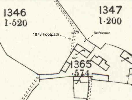
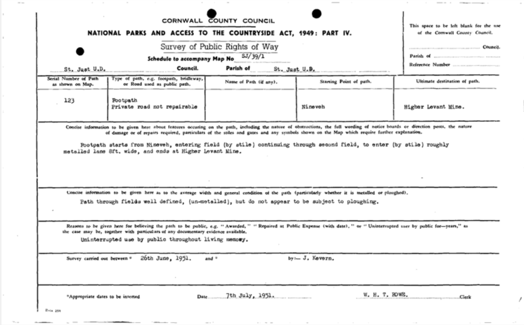
We also have a historical description from 1951 referring to a path entering a field by a stile and continuing through another field.
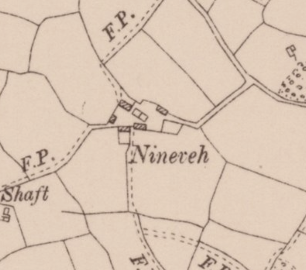
And I’ve since found another map.
An Ordnance Survey map revised in 1938 and published in 1945.
Sixty years after the original mapping, and just over a decade before the 1951 parish statement.
The footpath is still shown following the same route.
More interestingly, the map also shows the boundary where the substantial Cornish hedge stands today. The very boundary that Cornwall Council’s modern digital interpretation has the footpath passing through into our back garden.
So this isn’t simply a question of what a Victorian cartographer drew in 1875.
By 1938, the same arrangement was still being mapped.
Which makes the obvious question even harder to ignore.
When, exactly, did this footpath supposedly move into our garden?
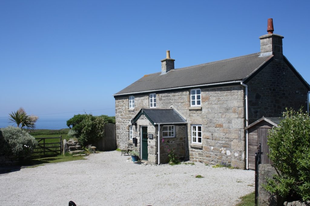
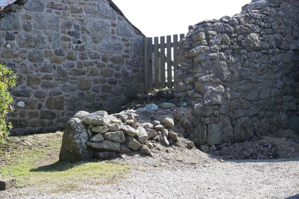
And we have photographs taken on the day we bought the property in June 2010.
Guess what’s in them?
The fucking stile.
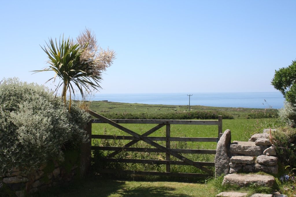
It’s in the location we associate with the historic route.
The gate beside it remains there today as the entrance point to the footpath.
Now, the Council has a different interpretation of the legal alignment.
That’s its position, and I understand that the Definitive Map is the current legal record.
But there’s a rather interesting historical question here.
If the path followed the route suggested by both the nineteenth-century and 1930s mapping, and the physical access arrangements we inherited in 2010 were consistent with that route, when exactly is the Council suggesting the alignment changed?
Was the route legally altered?
Was the Definitive Map drawn differently from the route that existed?
Or are we looking at the limitations of historical mapping being interpreted with rather more certainty than the evidence supports?
Because these are different explanations.
And they deserve different answers.
Now watch the stile
There’s another detail we’re investigating.
When we compare the historical mapping from the 1950s with the Definitive Map material produced in the 1960s, the depiction of the stile or access point appears to change.
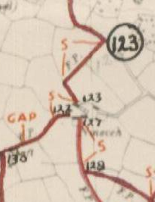
This matters because the location of a stile can provide useful evidence about where people historically entered or left a field.
But it also raises another question.
Did the stile actually move, or did its representation on the map change?
Those are not the same thing.
A symbol drawn differently on a later map doesn’t establish that somebody physically moved a substantial stone structure.
Equally, a photograph taken in 2010 doesn’t, on its own, establish exactly where a public right of way was legally recorded decades earlier.
That’s why we’re looking into the original records.
We want to understand how the route was surveyed, how it was transferred onto subsequent maps, and whether there is any documented explanation for the apparent discrepancy.
What I find difficult to accept is that this uncertainty can apparently be resolved simply by pointing at the modern digital line.
A brief history of nothing moving
There’s something else worth remembering.
We didn’t build the Cornish stone hedge.
We didn’t reconstruct the landscape to divert a public footpath.
We didn’t move the buildings after buying the property.
One of those buildings was reconstructed under a planning permission granted by Cornwall Council in 2015, with plans showing the path running alongside it.
We have photographs from before and after the reconstruction.
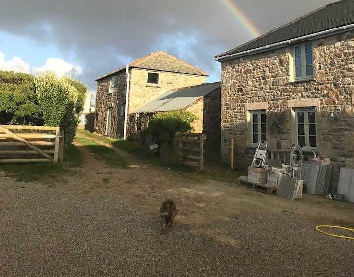
The route is still there.
People can still walk it.
Yet the Council’s planning decision states that this footpath, too, is obstructed.
Perhaps the Council has evidence demonstrating that the recorded legal alignment differs from the physical route.
If so, I’d like to understand it.
Because what I haven’t yet received is a satisfactory explanation of why the physical evidence we’ve supplied doesn’t alter the Council’s conclusion.
And that’s a rather important omission when you’re publishing statements about alleged obstructions in a planning decision.
We’ve now made a formal complaint
After weeks of correspondence with the Public Rights of Way team, we’ve taken the matter through Cornwall Council’s formal complaints procedure.
Not because we’re asking the complaints department to redraw a footpath.
Not because we think an 1875 Ordnance Survey map automatically overrides the Definitive Map.
And not because we expect the Council to accept our interpretation simply because we live there.
Our complaint concerns something more fundamental.
On 25 August 2026, Cornwall Council published this statement in the additional information accompanying our planning decision:
“Given the Public Rights of Way are already obstructed (both 114/123/1 and 114/127/1), a Public Path Diversion Order will need to be made to alter the route of the Public Rights of Way.”
That’s a serious statement.
It says two public rights of way are obstructed.
It says a diversion will be necessary.
And it sits on the public planning record of a property we’re trying to sell.
Our planning application didn’t propose altering either footpath.
Our planner raised the discrepancies before the decision was issued.
We supplied historical mapping.
We amended our drawings to show the Definitive Map alignments when the Council requested it.
And yet the decision still contained those categorical conclusions.
So our complaint asks:
What investigation established that these footpaths were obstructed?
What evidence ruled out inaccuracies or limitations in the mapped alignments?
And why was a paid diversion presented as necessary rather than examining whether the recorded routes themselves might require correction?
There is a formal process for investigating errors in the Definitive Map. It’s called a Definitive Map Modification Order.
The Council has acknowledged that this process exists and is relevant where the accuracy of a recorded alignment is disputed.
That’s a separate issue we’re prepared to investigate.
But it doesn’t explain why a planning decision about a development that didn’t alter the footpaths needed to declare that both were obstructed.
The problem with being precisely wrong
I’m a software engineer.
And this whole experience keeps reminding me of a problem we encounter in computing.
Precision is not accuracy.
A computer can represent a number to fifteen decimal places.
That doesn’t mean the original measurement was accurate to fifteen decimal places.
If you measure something with a ruler marked in centimetres and then enter the result into software that displays six decimal places, you haven’t magically improved the measurement.
You’ve just made the uncertainty less visible.
Maps are more complicated than rulers, of course.
But the underlying question is similar.
If the original record cannot show every intricate change in a path’s direction, what justifies treating a later digital interpretation as though it can?
Perhaps there’s additional survey evidence.
Perhaps there’s a documented legal change.
Perhaps the Council’s interpretation is correct.
I’m entirely prepared to consider those possibilities.
But show me the fucking evidence.
Because the physical route, the historical documents and the modern digital map don’t all appear to tell the same story.
And choosing whichever one happens to be the legal record doesn’t, by itself, explain how those differences arose.
Let people look
I’ve included the maps, photographs and historical records because I think people should be able to examine them for themselves.
Not everyone will agree with my interpretation.
That’s fine.
I’m interested in understanding what happened.
Was there a genuine historical change in the route?
Was there an error during the original mapping process?
Has a coarse historical line acquired a degree of digital precision it never possessed?
Or is there evidence we’ve simply not yet seen?
Those are all legitimate possibilities.
But when a public authority publishes a statement that two footpaths are obstructed and that the property owner will need to pay for diversions, I don’t think it’s unreasonable to expect it to explain precisely how it reached that conclusion.
Especially when that statement can follow the property into the conveyancing process.
The planning permission was granted.
The footpaths are still there.
The hedge is still there.
The buildings are still there.
And now we have a formal complaint asking Cornwall Council to justify what it has published.
In the meantime, I’m continuing to investigate the historical records.
Because somewhere between 1875, the 1950s, the 1960s and today, something appears to have changed.
Maybe the path.
Maybe the map.
Maybe simply somebody’s interpretation of it.
I’d rather establish which one before paying to divert anything.
And I’d quite like to sell my fucking house.